
Moin zusammen,
ich verwende https://morsle.fun/practice/callsign/?wpm=40&locked=false zum üben.
73 Michael
Moin zusammen,
ich verwende https://morsle.fun/practice/callsign/?wpm=40&locked=false zum üben.
73 Michael
sieht ja super aus und ist sicher in der Praxis auch gut zu gebrauchen.
Bin auch am überlegen mir einen QMX zu bestellen. Allerdings als Fertiggerät, da die Augen leider nicht mehr so gut sind um so ein Gerät selbst zu bestücken. Kann jemand sagen wie lange man in etwa auf das Gerät warten muss und ob da noch Zoll etc. berechnet wird?
73 Michael dk3hg
Hallo zusammen, eben entdeckt:
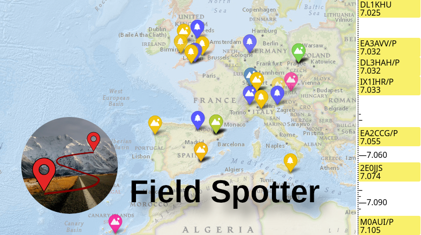
Das ist eine Karte wo spotter der letzten Stund (einstellbar) dargestellt werden.
Gruß
Michael
Hallo zusammen,
nur zur Info:
Ich habe so einen roten Fuß bei Ali gekauft. Nun wollte ich endlich meinen Stecker auf die Buchse schrauben - das geht auch die ersten 2-3 mm aber dann geht es nicht weiter. Ich habe es mit verschiedenen Steckern probiert und überall das gleiche Ergebnis das der Stecker nicht richtig auf die Buchse passt - sowas ist mir in meinen 56 Jahren Afu noch nicht passiert. Die Steigung des Gewindes der Buchse ist wohl nicht ganz korrekt hergestellt worden.
73 Michael
Hallo,
das TM110 hat eine dynamische Kapsel. Den VV kannst du warscheinlich einfach weglassen. Der ist für div Betriebsfunkgeräte gedacht die einen wesentlich höheren Pegel benötigen.
Kann jemand sagen wo man das Spiralkabel für das TM110 bekommen kann? Ich habe hier auch eins, aber mit defektem Kabel.
73 Michael
Hallo Jan,
vielen dank für den Tipp, habe mir das mal angesehen und denke das macht keinen schlechten Eindruck. Da der Pi sowieso in einem 19" Gehäuse sitzt und noch Platz ist kann das Netzteil dort noch gut mit rein.
Ja, diese Chinanetzteile sind mitunter echt übel was Störungen auf KW angeht. Aber für solche Erfahrungen ist das Forum ja gut geeignet.
73 Michael
Hey Michael, das ist auch bei dem Ladegerät dieser Gelben ALDI ActionCam der Fall.
Bei Reichelt gibt's ein NT, welches keine Probleme macht, mehr Leistung hat und günstiger ist!
https://www.reichelt.de/Schaltnetzteil…&ARTICLE=137080
Moin allerseits,
ich habe mir einen Pi 3 mit dem offiziellen Netzteil zugelegt. Einfach mal bei google "offizielles raspberry pi 3 netzteil" eingeben. Ich hatte auf Kurzwelle erhebliche Störungen durch rauschen mit etwa S 8 je nach Band und dann nach langem suchen endlich mal den pi 3 runter gefahren und das Netzteil aus der Steckdose gezogen. Auf einmal konnte ich wieder Kurzwelle hören, d.h. das das Grundrauschen von S 8 auf S 1 runter gegangen ist. Nachdem ich den Pi mit einem anderen Steckernetzteil wieder gebootet hatte war immer noch alles ruhig. Mich würde mal interessieren ob jemand ähnliche Erfahrungen gemacht hat. Mein 13,5 m Dipol hängt ca. 6 m über dem Gebäude mit dem Raspberry Pi.
73 Michael
Moin und frohes Weihnachtsfest,
ich habe hier ein 13,2 Volt Schaltnetzteil Type 9320 von Mascot. Da es diese Netzteile auch mit anderen Ausgangsspannungen gibt, müsste es möglich sein das Netzteil von 13,2 Volt auf 9 Volt umzubauen. Leider habe ich keinerlei Schaltungsunterlagen über dieses Netzteil. Mit dem intern eingebauten Poti komme ich nur auf ca. 12 Volt.
Ich suche entweder ein Schaltbild (im Netzt habe ich nichts gefunden) oder eine Umbauanleitung.
73 Michael
Moin,
ich habe einen wunderschönen 20 dB Leistungsabschwächer (20 Watt) mit versilberten N Koaxanschlüssen
die total schwarz geworden sind. Nun suche ich eine Möglichkeit diese Oxidschicht möglichst chemisch zu entfernen.
Hat jemand eine Idee was man da machen kann?
73 Michael
Moin Antennenbauer,
hier ist auch noch ein nettes Antennen Analysator Project
http://www.ea4frb.eu/sark100.html
Das ganze ist als Bausatz erhältlich. Hat hier jemand das Gerät schon mal aufgebaut? Ich wäre an Erfahrungsberichten interessiert.
73 Michael (dk3hg)
Original von DL2FI
Hallo Jürgen,
damit stehst du nicht alleine da, ich höre häufig QSO´s bei denen die Partner locker 300-400 Hz auseinander liegen.
Um dem abzuhelfen haben wir schon vor längerer Zeit im QRP-Report eine kleine Schaltung veröffentlicht, die eine LED dann aufläuchten läßt, wenn man genau auf der QRG der anderen Station sitzt. Ich bin gerade dabei, daraus einenn kleinen bausatz zu machen. Man kann diese kleine Schaltung aber genau so gut auf Lochraster o.Ä. aufbauen, es sind ganz wenig Bauteile..
Moin,
ich kann mich an die Schaltung erinnern, finde nur den Beitrag (oder das Heft) nicht mehr wieder.
Kann bitte mal jemand schreiben in welchem Heft das war?
Danke und 73 Michael
Original von DL2FI
Nein Michael, wir spezifizieren 10-15 Volt.
Prima! Dann werde ich auch die 10 Zellen verwenden. Vielen Dank auch an die anderen OM's für die interessanten Hinweise.
73 und schönes Wochenende
Michael
Original von dl4jal
Hallo, ich habe mal in Pascal fuer mein Logbuch eine kleine unit geschrieben. Vielleicht hilft Euch das weiter. Die Formatierung der Datei ist eventuell im Unixformat, da ich schon ein paar Jahre nur noch mit Linux arbeite.
Viel Spass beim studieren der Datei.
73 DL4JAL Andreas
Hallo Andreas,
ich benutze auch nur Linux und falls von Interesse, im Paket wampes http://x-berg.in-berlin.de/cgi-bin/viewcv…/wampes-import/ ist ein Kommandozeilentool "qth" enthalten - sieht dann so aus wenn man es ohne Parameter aufruft:
$ qth
Usage: qth <place> [<place>]
<place> ::= <locator>
<place> ::= <grd> [<min> [<sec>]] east|west
<grd> [<min> [<sec>]] north|south
<place> ::= <gauss-krueger-coordinate>
mmmmmm[m]hhhhhh[h]
7*m+7*h: normal; 6*m+6*h: O2 (ex viag)
[-nat] [-h value] [-d arg] <place> [arg2 [..]]
-n: nmea compatible output.
[arg2 [arg3]] will be head/tail.
if present, a GPS checkum is automaticaly added.
-a: nmea $GPGGA header. arg2 may be user specified suffix
-t: nmea timestamp for $GPGGA
-i: stamp $GPGGA information as invalid
-h: give height above sea [and metric], for e.g. 100M
-d: $GPGGA horizontal precision, for e.g. 1.5
Examples: qth jn48kp
qth ei25e
qth 8 53 28 east 48 38 33 north
qth 8 53.47 east 48.642 north
qth jn48aa 9 east 48 30 north
qth 345827543286
qth 34582705432860
qth -n jo33sm
qth -nat 34582705432860
73 Michael
Hallo Peter,
danke für den Hinweis mit 9 Zellen. Ich hatte schon überlegt einen Akku mit 10 Zellen zu verwenden, der würde dann bei 12,5 Volt liegen. Allerdings mache ich mir Sorgen wenn der Akku voll geladen ist, d.h. dann ist jede Zelle auf 1.5 Volt aufgeladen. In diesem Fall müsste das Gerät 15 Volt verkraften. Ist das evtl. für Miss Mosquita zu viel? In der Spezifikation habe ich etwas von 14 Volt gelesen.
73 Michael
Moin,
ich möchte in das Gehäuse einen Akku einbauen um möglichst wenig Einzelteile mitschleppen zu müssen wenn ich portabel qrv bin. Jetzt stellt sich die Frage wieviel Zellen ein Akku haben sollte.
Was habt Ihr für Erfahrungen bzw. Empfehlungen zu diesem Thema.
73 Michael
Hallo Peter,
sieht prima aus - wo kann man diese Gehäuse beziehen?
73 Michael